Map Measure
This plugin enables you to measure distances on the map using a "ruler" tool.
How to use
1. Log into your application
2. Click on the Map Measure Tool icon in the toolbar

3. After selecting the tool, you can draw lines or polygons on the screen
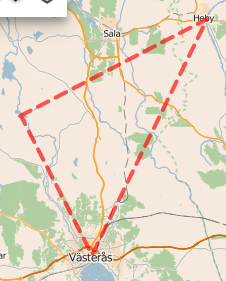
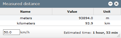
At the right of the screen, a window will pop up and display the distance measurements according to your selection.
Note: the estimated travel time statistics are based on the speed according to the drawing.
Was this article helpful?
That’s Great!
Thank you for your feedback
Sorry! We couldn't be helpful
Thank you for your feedback
Feedback sent
We appreciate your effort and will try to fix the article